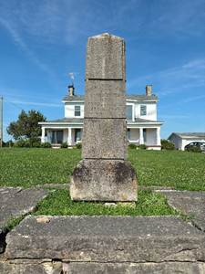
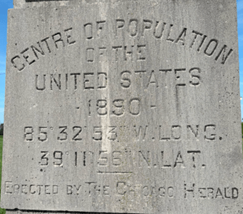
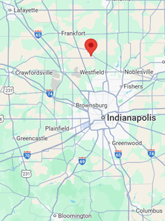
In July this year I had the opportunity to take a friend to visit a friend outside of Westport Indiana. Many of you may not know where Westport Indiana is … it’s between Greensburg and North Vernon…east of Columbus about 20 miles. We visited this friend so I could see the marker erected in 1890 designating the center of the U.S. population. The Census Bureau defines this as “The mean center of population is determined as the place where an imaginary, flat, weightless and rigid map of the United States would balance perfectly if all residents were of identical weight.” https://www.census.gov/data/tables/time-series/dec/center-pop-text.html This census page locates the center from 1780-2020. It is interesting to note how the population shifted westward and more recently southwardly.
The ”Center of population” was in Indiana from 1890-1940 then moved to Illinois and finally in 2020 it was in southern Missouri. This tells me the Great Plains still holds less population than the East Coast. Think about all the large urban areas in the East—New York, Philadelphia, Atlanta, Miami….with the west having Los Angeles, Phoenix, Seattle…
By 1910 it had moved to Bloomington Indiana which also celebrated with a marker described by the Bloomington Daily Telephone newspaper, October 11, 1911 as a “On the center of the platform was a circular block of Oolitic stone, with the words “Center of Population U.S.A. 1910 Census” cut into its front and top and outlined in gold leaf. A flagpole in the center of the stone extended to a height of 75 feet, topped by a large American flag. Below the flag was a pennant reading “Center of Population U.S.A. 1910.”” I’m looking for the marker in Bloomington but a friend forwarded me a photo of the stone and it does say “Center Population U.S.”.

How does this differ from the “geographic center”. But even this statistically was more involved than I had expected being defined “The one employed by the National Ocean Survey is probably best termed as the center-of-gravity method.” https://www.ngs.noaa.gov/PUBS_LIB/GeoCenter_USA1.pdf In 1918 it was pretty well where one might expect: near Lebanon, Kansas. But the admission of Hawaii and Alaska required it be re-calculated so by 1959 it was approximately 17 miles west of Castle Rock, Butte County, South Dakota.
Now when I explored the “geographic center of the U.S. population” it ended up back home again in Indiana: Gibson County, Indiana for 2020. I always loved the Census publications but even more enthralling to me were the definitions (always very precise) used by our government publications. The Census Bureau even calculates it to the State…see https://www.census.gov/geographies/reference-files/time-series/geo/centers-population.html (Indiana,6785528,+40.144178,-086.251589).
See what retirement does for a Gov’ Doc Librarian! I did enjoy seeing the marker in Westport and would give you directions if you decide to visit.
This blog post was submitted by Lou Malcomb, IU-Bloomington, retired.
